US50/ South Shore Community Revitalization
The US 50 / South Shore Community Revitalization Project is a bi-state community development project that realizes the redevelopment vision which has been in community plans for over 40 years.
For years, traffic congestion through the US 50 corridor at Stateline has adversely impacted Lake Tahoe’s water clarity and the quality of visitor experiences. Transportation choices play an important role in mitigating these impacts because more than 70 percent of the particulates impacting Lake Tahoe’s clarity comes from the current transportation system and built environment. The US 50 project, locally known as the “Loop Road” project, aims to evolve Lake Tahoe’s transportation system and includes elements focusing on affordable housing and economic development needs, pedestrian and bike safety enhancements, expanded transit options, and neighborhood and environmental improvements to address air and water quality and greenhouse gas reductions, consistent with the City of South Lake Tahoe and Douglas County Master Plans, Local Area Plans, and the Tahoe Regional Planning Agency’s (TRPA) Land Use Plan.
The project consists of four main elements:
Transportation System Improvements
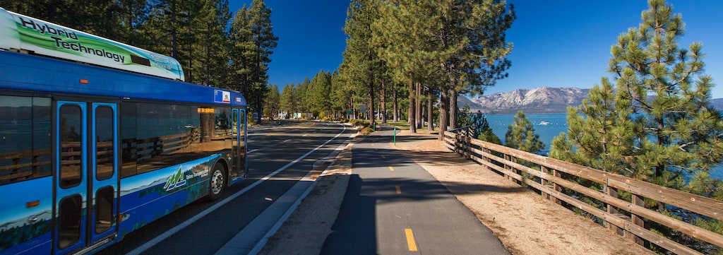
The US 50 project realigns the one-mile section of Highway 50 from Pioneer Trail in South Lake Tahoe to Lake Parkway in Stateline to the east. The current US 50 will become a local street corridor, with a two-lane pedestrian and transit-oriented main street with expanded sidewalks, bike lanes, transportation services, and improved access to retail, dining, and entertainment. Consistent with regional transportation and local land use plans, the US 50 project shifts the through traffic away from the main street area, which will help reduce congestion and improve emergency access and safety. With transit-focused circulation around the tourist core, the US 50 project will create Lake Tahoe’s single largest mobility hub, a focal point of connectivity to multiple transit options. Mobility hubs help make travel safer and more convenient, while improving air and water quality by lessening greenhouse gas emissions from idling vehicles and reducing fine sediment particles from stormwater runoff.
Main Street Management Plan
Jointly led by TTD and TRPA, the Main Street Management Plan kicked off in summer 2019 after the approval of Alternative B. The Plan will provide design concepts and policy recommendations to refine the vision for the new lcoal street corridor. This Plan is one of seven components that must be completed as part of the project permit. The development of the Plan is facilitated by a Staff Steering Committee, made up of representatives from TRPA, TTD, the City of South Lake Tahoe, and Douglas County. Click here for more information about the Main Street Management Plan.
Affordable Housing
The US 50 project also includes elements to address the overwhelming shortage of affordable housing in the South Shore Lake Tahoe community. TTD committed to provide 109 housing units, exceeding the 76 replacement units required as project mitigation. The 76 units are required to be constructed prior to the displacement of any residents for any part of the project and will be built within a quarter mile of the project area. TTD has been collaborating with community partners to encourage additional interest in the South Shore’s transit-oriented development areas to meet its goal of 200 total new affordable housing units. Replacement housing is targeted to affected residnets, who will have the first right of refusal. Qualified residents will receive financial and relocation assistance and the opportunity to qualify for new deed-restricted affordable housing. The new housing will be transit-accessible and remain affordable through permanent deed restrictions.
Neighborhood and Community Improvements
The US 50 project addresses improvements the community has needed for decades by creating a destination where people can more easily access mountain and lake amenities, lodging, retail, and entertainment by foot, bike, or transit. The US 50 project incorporates expanded transportation options to calm traffic, alongside neighborhood improvements that include additional transit connections, a new pedestrian bridge, bike lanes, trail connections, sidewalks, parks and green space, street lighting, signage, noise mitigation, and more. With a safer, walkable downtown area, improved access to local businesses, public parking, and connectivity to more transportation options, the community will be more accessible for shopping, entertainment, and events, helping enhance the resident and visitor experience.
Location
From Pioneer Trail in California to Lake Parkway in Nevada, the 1.1-mile project area is generally considered South Shore’s “downtown.”
Redevelopment has drawn attention to a lack of sufficient infrastructure to safely support growing resident, commuter and visitor use.
Most of the proposed project designs realign this section of US 50 behind the casinos to calm traffic and allow “complete street” improvements.
- US 50 Final EIR EIS EIS Vol.1
- US 50 Final EIR-EIS-EIS Vol 2 Appendices
- US 50 Loop Draft EIR EIS Vol.1
- US 50 Loop Draft EIR EIS Vol.2
- Draft EIR Appendix A US 50 Scoping Report
- Draft EIR Appendix B Maps Of Parcel Acqusition 060916
- Draft EIR Appendix C Alternatives Dismissed
- Draft EIR Appendix D US 50 Section 4(f) 10.06.16
- Draft EIR Appendix E Policy Consistency Tbl 10.06.16
- Draft EIR Appendix F Relocation Study
- Draft EIR Appendix G VIA 01 28 15 (Revised)
- Draft EIR Appendix H Non Discrimination Statement
- Draft EIR Appendix I Traffic Operations Analysis Update
- Draft EIR Appendix J AQ GHG Modeling Data
- Draft EIR Appendix K Noise Data
- Draft EIR Appendix L Tree Survey Memo
- Draft EIR Appendix M Special Status Species Tables
- Draft EIR Appendix N Linear Park Exhibits
- Hwy50 Flyer Faq English
- Hwy50 Flyer FAQ Tagalog
- Hwy50 Flyer FAQ Spanish
- US50 Business Displacee 3 31 16[1]
- US50 Desalojo De Negocios
- US50 Residential Displacee 3 31 16[1]
- US50 Residencial Desplazada
Timeline
| 1980 | Bypass concept first proposed |
| 1990s | Some analysis of a loop road system completed in conjunction with Stateline and City of South Lake Tahoe Community Plans |
| 2003-2004 | Early public outreach and initial transportation study |
| 2009 | Project transitioned to TTD |
| 2010 | Water quality study, the Lake Tahoe Total Maximum Daily Load Report (TMDL), identifies transportation system as primary source of pollutants clouding Lake Tahoe |
| November 2010 | Value Analysis published |
| 2012 -2015 |
Engineering and environmental technical studies for Environmental Document (ongoing) |
| 2012 to present | Public workshops (ongoing) |
| Summer 2013 | Business and Community Review Committees formed |
| 2017 | Draft Environmental Document completed and released for public review and comment |
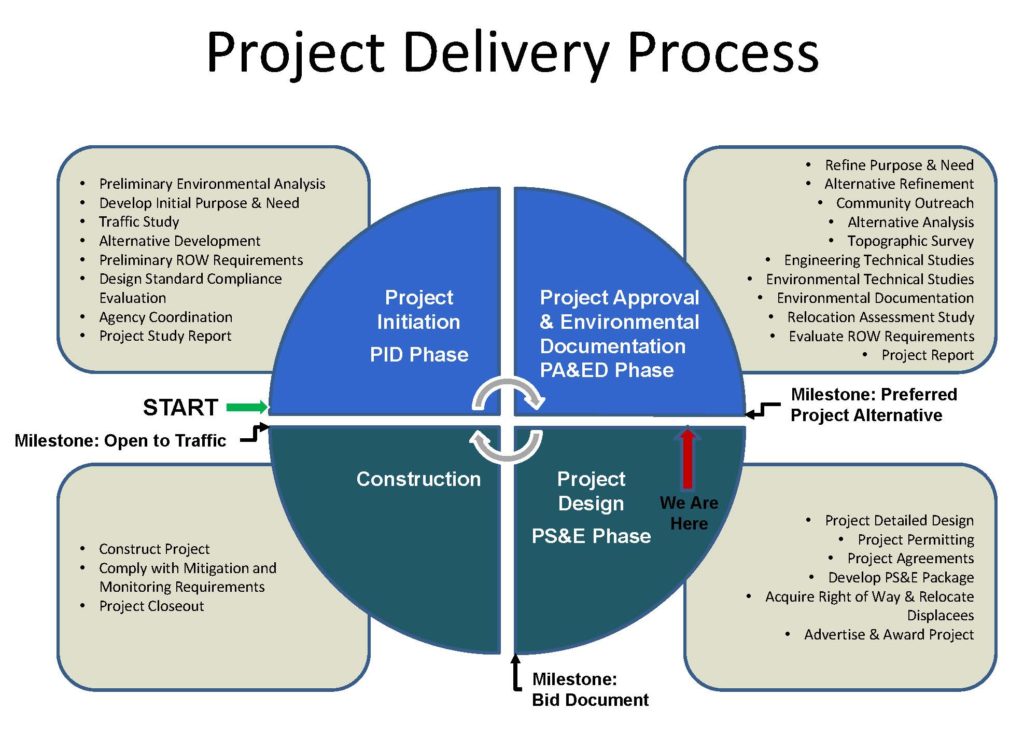
| Fall 2018 | Final Environmental Document approved by the responsible agencies |
| November 2018 | Alternative B, the locally preferred alternative, approved for final design and construction |
| 2019 | Main Street Stakeholder group formed. TRPA to hold four meetings as part of the permit conditions. |
| 2019-2020 | Enter final design phase (on-going) |
| Construction | Subject to funding approvals |
