Category: Planning
Tahoe Transportation District receives SMART grant for traffic data collection
New traffic counts will support regional transportation planning
March 20, 2024
Tahoe Transportation District (TTD) received a Strengthening Mobility and Revolutionizing Transportation (SMART) grant from the US Department of Transportation (USDOT) to plan for and evaluate multimodal traffic data collection technologies. This will allow the region to better understand the number of vehicles entering and leaving the Lake Tahoe Basin as well as other transportation needs to help manage traffic operations and safety concerns.
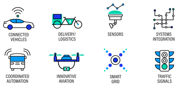
Types of Projects supported by the USDOT SMART Grant program
Source: USDOT, SMART Grants Program | US Department of Transportation
FAQs
Who is involved?
TTD, along with the Tahoe Regional Planning Agency (TRPA), US Department of Transportation, Nevada Department of Transportation (NDOT), California Department of Transportation (Caltrans), US Forest Service, and local governments in the Tahoe region, are collaborating to identify the most suitable locations for this traffic data collection pilot program.
What is the SMART grant program?
The Bipartisan Infrastructure Law (BIL) created the competitive SMART grant program to provide funding to public agencies to conduct demonstration projects focused on advanced smart community technologies that improve transportation efficiency and safety. The TTD grant will test data collection technologies in the Lake Tahoe Basin, which has unique challenges related to climate and availability of utilities for traditional data collection methods.
How long will the project last?
SMART grants are intended to be completed within 18 months. The project is currently in the planning stage and data collection is expected to begin during the summer of 2024.
Where and how will data be collected?
TTD, TRPA, and other partner agencies are currently working to identify the most suitable technology and locations for traffic data collection. Priority locations may include entry points into the Lake Tahoe Basin and high-traffic areas across the region. Information that could be used to identify individuals, such as license plates, will NOT be collected.
Why is this project needed?
The Lake Tahoe Region has unique travel patterns due to a combination of local residential and commercial trips plus visitation from around the region and the world. However, there is limited information about exactly how many vehicles are travelling around the region and how this varies by season, holiday periods, time of day, and specific location. Information about how many people walk, bicycle, or use other ways to travel is also limited. Once developed through this grant program, transportation planners will use this data to better understand and prepare for transportation needs.
How will the data be used?
TTD and TRPA will use the data to gain a better understanding of traffic movement into and through the Lake Tahoe Basin by season and time of day. This information will be used to identify transportation needs and potential solutions to meet the unique travel demands of the region. Information will be made available to the public though TRPA’s Tahoe Open Data web portal.
Public Draft Tahoe Basin Hazard Mitigation Plan Available for Comments
The Tahoe Transportation District and Tahoe Resource Conservation District have developed a Hazard Mitigation Plan (HMP). An HMP is required by a federal law, known as the Disaster Mitigation Act of 2000 (DMA 2000), to receive certain types of FEMA grant funding.
The planning process took one year to complete. The plan addresses climate change, dam failure, drought, earthquake, flood, landslide, wildfire, and winter storm. For each hazard identified, short- and long-term strategies were developed to reduce or eliminate the hazard impact on each district. Strategies were developed using FEMA success stories and best management practices, FEMA job aids, local and regional plans and reports, and input from planning committee members and sustainability and transportation practitioners.
The plan was organized to follow FEMA’s Local Mitigation Plan Regulation Checklist, which demonstrates how hazard mitigation plans meet the DMA 2000 regulations. A copy of the Regulation Checklist can be found here: https://www.fema.gov/sites/default/files/documents/fema_local-mitigation-planning-handbook_052023.pdf
The draft plan is available for review and comment until Monday, October 16. Click here to view the HMP.
Tahoe Basin Hazard Mitigation Plan Notification
The Tahoe Transportation District and Tahoe Resource Conservation District, in coordination with regional partners, are developing a Hazard Mitigation Plan. The purpose of this plan is to profile the natural and human-caused hazards in our area, determine the impacts of those hazards on our multi-modal transportation system and land conservation efforts, and develop strategies to mitigate future disasters.
The planning process, a requirement of the Federal Emergency Management Agency (FEMA), will include a public review period, expected to occur this winter. Once approved by FEMA and adopted by both agencies, Tahoe Transportation District and Tahoe Resource Conservation District will be eligible for certain types of federal funding to help create a more disaster resilient Lake Tahoe Basin. Because this plan is funded through the California Office of Emergency Services, certain requirements in the plan will only address the California side of the Lake Tahoe Basin. It is our hope that future updates of the plan will include the Nevada side of our community. In the meantime, to learn more about hazard mitigation, please visit: https://www.fema.gov/emergency-managers/risk-management/hazard-mitigation-planning